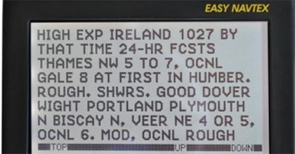


Learning how to navigate a boat involves mastering both digital and traditional nautical charts. While commercial systems such as the ubiquitous Electronic Chart Display and Information Systems (ECDIS) and modern apps like Navionics provide digital solutions and electronic chart display systems to check your position, review electronic chart data, weather forecasts, and even plot routes, it remains crucial in the marine environment to be able fully to understand and confidently read traditional nautical charts. This ensures you can cross-check your digital navigation plans with traditional methods for safe and efficient navigation.
The Importance of Nautical Charts
Nautical charts are rich with information, including charted depths, key landmarks, and navigational aid symbols. Understanding these symbols is vital for safe navigation. This guide will explore some of the most common nautical chart symbols and their meanings. These symbols are standardized by the International Hydrographic Organization.
Depths
Depth information is one of the most critical features on a nautical chart. It helps ensure there is enough clearance between the underside of your hull/keel and any obstacles around or below you. Depths are typically represented by contour lines that indicate the depth of the water at specific locations, marked with numbers representing the depth in feet or meters. Symbols indicating shallow areas, such as rocks or shoals, are also common.
Navigational Aids
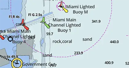
Navigational aids, or aids to navigation (ATON), are markers that help mariners navigate safely. These are represented by various symbols and chart symbols indicating their type and location:
- Lighthouses: Often shown as a tower with a light on top.
- Buoys: Indicated by symbols representing their type and color. In apps like Navionics, you can also see the buoy’s name and its light flashing sequence.
Obstructions
Obstructions are hazards that mariners need to avoid, including rocks, shoals, wrecks, and other underwater dangers. These are represented by symbols indicating their location and type:
- Rocks: Typically shown as a small island or circle.
- Wrecks: Often depicted as an “X” or a shipwreck icon.
Anchorages
Anchorages are safe areas where mariners can anchor their vessels, represented by anchor-like symbols. These symbols also provide depth information to ensure the water is deep enough for anchoring.
Channels
Channels are safe routes for navigating into marinas, anchorages, or passageways. Symbols for channels indicate their location, width, and sometimes the direction of flow and any associated hazards.
Landmarks
Landmarks are prominent features on land used for navigation, represented by symbols indicating their type and location, such as a church depicted with a building and a cross.
Fishing Areas
Fishing areas, where commercial and recreational fishing is permitted, are shown by symbols indicating their location and the type of fishing allowed.
Military Zones
Military zones, where military activities occur, are represented by symbols indicating their location and activity type.
How to Read Nautical Chart Symbols
Understanding nautical chart symbols is essential for interpreting the information on a chart accurately. Here are some tips:
- Colour Coding: Water depths are indicated by colors—blue for deep water, green, yellow, and brown for progressively shallower depths.
- Land and Water Features: Land features are usually brown, while water features are blue or green. Common symbols include shorelines, mountains, buildings, buoys, channels, wrecks, and shoals.
- Navigational Hazards: Symbols for hazards like rocks, wrecks, and obstructions are typically black or red.
- Additional Information: Charts often include details like depth soundings, tides, currents, and navigation aids such as buoys and lighthouses.
- Legend: Familiarize yourself with the chart’s legend or key, which contains important information about the symbols used.
- Electronic Charting Systems: Modern GPS devices or apps like savvy navvy simplify reading nautical charts, providing detailed information and allowing zooming. Always carry a paper backup chart in case of electronic failure.
Understanding the symbols, abbreviations, and terms used on nautical charts is crucial for safe and effective navigation.
Common Nautical Chart Symbols
- Depth Soundings: Numbers along a contour line indicating water depth.
- Lighthouses and Beacons: Towers with lights marking hazardous navigation areas.
- Rocks, Shoals, and Obstructions: Circles or shapes with dots in the middle.
- Wrecks: Shown as an “X” or a distinctive shape.
- Channels: Lines with depth soundings on either side.
- Anchorage Symbols: Anchor icons indicating safe anchorage locations.
- Buoyage: Symbols indicating the location and type of buoys, including their color and shape, covering all the symbols necessary for navigation and maritime safety.
Navigational Symbols and Abbreviations
Marine navigation uses navigational symbols, symbols abbreviations, and abbreviations to convey important information concisely. Here are some common examples:
- Lat: Latitude
- Long: Longitude
- CHTS: Charts
- DR: Dead Reckoning
- Hdg: Heading
- Fathoms: Depth measurement
- M: Magnetic
- True: True direction
- ANCH: Anchorage
- ATON: Aids to Navigation
- Brg: Bearing
- CH: Church
- CRAN: Crane
- DNG: Danger
- FISH: Fishing
- HW: High water
- LW: Low water
- RACON: Radar Beacon
- SHL: Shoal
- SNDG: Sounding
- SP: Signal Post
- WDSP: Windsock
Safety Symbols
Nautical safety symbols are crucial for indicating hazards, navigational aids, and other important information related to maritime safety. Some common safety symbols include:
- Anchorage Symbol: Circle with an anchor inside.
- Buoy Symbol: Floating device used as a navigational aid or hazard marker.
- Rocks or Shoals Symbol: Group of rocks or a triangle with a dot.
- Wreck Symbol: Sunken ship or crossed-out anchor.
- Safe Water Mark Symbol: Diamond with horizontal stripes.
- Restricted Water Symbol: Diamond with vertical stripes.
- Depth Contour Symbol: Series of concentric circles.
- Landmark Symbol: Small building or tower.
- Compass Rose Symbol: Star with directional arrows indicating true north.
Using Nautical Charts
To use nautical charts effectively, follow these tips:
- Understand the Symbols: Familiarize yourself with the meanings of chart symbols before setting out. You can use a useful guide such as Chart 5011, actually a book describing every chart symbol
- Use a Compass Rose: This shows the orientation of cardinal directions.
- Calculate Distances: Charts provide distance scales in nautical miles.
- Note Tide and Current Information: This is crucial for planning routes and avoiding dangerous conditions.
- Check for Updates: Regularly update your charts to reflect environmental changes.
- Use a Chartplotter: Modern boats with chart plotters and apps like savvy navvy display real-time locations.
- Practice Safe Navigation Techniques: Combine tools and techniques, including charts, GPS, and visual observations.
Understanding electronic navigational charts along with traditional paper charts is essential for safe navigation.
Differences in Nautical Chart Symbols
Nautical charts use various symbols to represent different features and hazards. Understanding these differences is key:
- Depths: Represented by colors and contour lines indicating the shape of the sea bottom.
- Rocks and Reefs: Depicted with different symbols based on their nature and location.
- Lighthouses: Varying symbols based on their type and function.
- Buoys: Differentiated by color and shape.
- Wrecks and Obstructions: Different symbols indicating their nature and location.
Always consult the chart’s legend or key to understand the specific symbols used. The National Geospatial-Intelligence Agency plays a crucial role in standardizing these nautical chart symbols, ensuring consistency and reliability across navigational documents.
By mastering nautical chart symbols, mariners can navigate safely and efficiently, combining the best of both traditional and digital navigation methods.